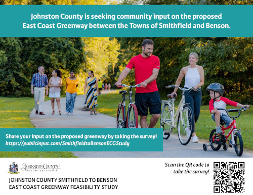
Public Input Needed - Smithfield to Benson East Coast Greenway Feasibility Study
Johnston County and partners are soliciting community input on the Smithfield to Benson East Coast Greenway Feasibility Study.
Community members can provide feedback by taking an online survey at the link included below or a paper copy distributed by partner agencies.
The survey will be open for public comment through Friday, November 10, 2023.
https://publicinput.com/SmithfieldtoBensonECGStudy
For more information, please continue below
SMITHFIELD TO BENSON EAST COAST GREENWAY FEASIBILITY STUDY
PROJECT OVERVIEW
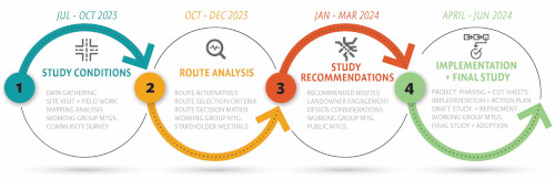
The proposed Smithfield to Benson East Coast Greenway (ECG) is a 15–17-mile corridor in Johnston County connecting the existing greenway in Smithfield to Benson. The corridor primarily follows US-301 beginning along the Neuse River in Downtown Smithfield at the terminus of the Buffalo Creek Greenway to the Johnston County line, outside of Benson town limits. The Smithfield to Benson East Coast Greenway is a critical missing link in the County’s greenway network and is the proposed corridor for gap segments of the East Coast Greenway and Mountains to Sea Trail. The Smithfield to Benson ECG Feasibility Study will evaluate potential route scenarios along roadways and off-road corridors to determine the preferred route. The study will also develop cost estimates and an implementation plan to construct the greenway.
The project is led by Johnston County, with the following as supporting partners: the Town of Smithfield, the Town of Benson, NCDOT, NC State Parks, and the ECG Alliance.
About the East Coast Greenway
The East Coast Greenway is a 3,000-mile walking and biking route from Maine to Florida that connects major cities, small towns, and parklands along the Eastern Seaboard. In North Carolina, the ECG route passes through the cities of Durham, Raleigh, Fayetteville, and Wilmington and primarily follows the Neuse River and Cape Fear River corridors across the state. The ECG is currently 28% complete. The longest continuous stretch of completed trails is in North Carolina, which is comprised of the 72-mile span of greenways and trails through Durham, Wake, and Johnston Counties. The proposed Smithfield to Benson ECG Greenway corridor aims to expand the connected greenway network via the planned Neuse River Trail extension to over 100 miles in the region, completing the ECG corridor through Johnston County.
About the Mountains to Sea Trail
Additionally, portions of this segment have the potential to be co-located with the MST, which is North Carolina’s flagship state trail. The MST stretches 1175 miles from Clingmans Dome on the Tennessee border to Jockey’s Ridge State Park on the coast. The trail in the southeast portion of the state was originally envisioned to follow the Neuse River to New Bern, a route that is still under development. In 2017, a new route, the Coastal Crescent Trail through the Cape Fear Arch and Onslow Bight, two geologic regions considered among the most ecologically significant in North America, was made an official part of the Mountains-to-Sea Trail. Currently, the existing trail is a natural surface footpath and uses connecting roads to complete the route through the diverse natural and historic landscapes and welcoming communities.